


All about the ice
by Catalina Myers |
Each winter, the United States Coast Guard (USCG) monitors the 6,700 miles of shoreline, including 1,500 miles of shared international coastline with Canada, on the Great Lakes. USCG District 9 is responsible for ensuring the safe passage of commercial vessels, fishing boats and recreational users traveling on the lakes during the treacherous winter months, when ice can reach eight inches deep or more at the height of winter.
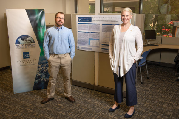
Arctic Domain Awareness Center fellows Seth Campbell and Kelsey Frazier have helped develop the Ice Condition Index used to quantify ice conditions for vessels navigating the Great Lakes, and now for the Arctic. (Photograph by James Evans / University of Alaska Anchorage)
It's a difficult task and an important one, ensuring that the goods and services barged across the lakes arrive at their destination and that the captains navigating the Great Lakes during the winter months have the information to know whether to venture out into the watery, icy expanse. It's why the Department of Homeland Security (DHS) called upon the Arctic Domain Awareness Center (ADAC), headquartered in Anchorage, to help create an index - a way for the USCG and other maritime organizations, and those traveling the lakes regularly for work or recreation, to determine the viability of travel on the lakes on any given day.
"When mariners are on the Great Lakes and we have both, U.S. Coast Guard, Canadian Coast Guard and all of the commercial ships that are transiting back and forth carrying goods and cargo, their decision-making process was always based off of personal experience and what they could see," said Kelsey Frazier, a UAA mechanical engineering student and current ADAC fellow. "There wasn't a scientific method for, 'Should I take my vessel out in this ice and will I make it?' The Coast Guard, honestly I think, got tired of rescuing people who really shouldn't have been out there."
It's how ICECON, or the ice condition index, was born.
The ice index
In 2016, DHS realized the need to create a more effective way to categorize the ice navigability to alert mariners traveling the Great Lakes. The ICECON project is based on a Canadian model to determine the different types of ice that vessels encounter when traveling the Great Lakes. Scientists have categorized different types of ice, like brash ice, large floating pieces of ice that is the wreckage from colliding ice flows, or pancake ice, round 10-inch pieces of ice that can be up to about four inches thick, as well as ice with snow cover, black, black ice over water or large plains of rough consolidated flows. All of these different types of ice, including their thickness as well as environmental conditions, were needed to be categorized to help vessels know whether their ships could travel and navigate the conditions on the lakes.
"ICECON needed to establish a couple of basic things," said alumnus Seth Campbell, B.S. Mechanical Engineering '14, M.S. Civil Engineering, '19 and ADAC fellow. "First, it needed to establish a 'go-or-no-go' condition for ships that are in port. It also needed to take into account the ship's worthiness and lastly, we needed to be able to compare the ships worthiness against the ice conditions index, ice concentration and ice thickness."
Campbell said that the ice condition index also factors in environmental parameters like temperature, ice concentration and ice thickness into the overall index reporting. All of these criteria combined help the USCG, the Canadian Coast Guard and commercial vessels determine if they should travel the lakes. He said dispatching USCG's ice-breaking ships is costly, and an even bigger economic loss is having to rescue a vessel that has gotten stuck out on one of the vast frozen lakes. ICECON helps USCG and those with commercial interests on the Great Lakes save economically.
"We're comparing the environmental ice condition index to the ship's maximum worthiness and that gives you an idea of whether you should go or not," Campbell said. "Additionally it's [ICECON] intended to establish whether or not if a ship that's out there on the lake - and ice conditions can change, they're dynamic - needs assistance from an icebreaker to travel through the lake."
Campbell has been working on the ICECON project since 2017 and has been collecting data based on the five criteria the U.S. National Ice Center (NIC) the tri-agency operational center that provides ice analysis for U.S. armed forces and government agencies, which included the aerial ice concentration, ice thickness, air temperature, wind speed and direction, and ice type.
He said collecting some of the requested data was easier to obtain than others, and through his research determined that factors like temperature, ice thickness, ice concentration and ice type played a more important role in contributing information to the ice index.
At this point, Campbell's research has been handed off to U.S. NIC, which the USCG is using to beta-test a live ice forecasting model for ship captains traveling the Great Lakes. Which, now that Campbell has earned his master's degree and the project has been completed, he's looking to move on to other endeavors and has officially handed off the baton to Frazier, who is stepping in for ICECON 2.0, or Arctic ICECON.
Arctic ICECON
"At the end of ICECON, the idea was floated of having an Arctic version," said Frazier. "At the time the research looked like just taking what was done in the Great Lakes and translating that to the Arctic. This will be a really easy process, we thought, but the more we dug into it the more we discovered that these are two completely different regions that need to two completely different ICECONs."
Frazier said all the research that had been done to determine ice factors for vessels traveling the Great Lakes wasn't applicable in the Arctic. She said the data sources were different, the types of ice ships would encounter was drastically different and the physics of the ice in the Arctic was completely different due to being in saltwater from the sea versus freshwater on the Great Lakes. It was a surprise to the researchers.
"It required that we completely reevaluate our process," Frazier said. "It was an exciting opportunity for us researchers, but gave our administration a little heartburn."
But according to District 17, the USCG office based out of Kodiak and Juneau, there is a need for more in-depth research of Arctic ice and a way to determine navigability of ships traveling in the far North. Frazier said ADAC completed their initial feasibility study and are continuing research on Arctic ICECON, and that the project will become more timely as the Arctic continues to warm and traveling through historically impassable regions becomes more plausible in the future. Frazier said Arctic ICECON research is important because in the following decades, commercial travel through the Arctic might be possible, which opens up a whole new economic opportunity for the transfer of goods and services in the U.S. and across the globe.
"We've seen how changes in the Arctic are going to impact Alaska and the rest of the United States and that's why Arctic ICECON is crucial," said Frazier. She said other circumpolar north countries like Russia and in the Netherlands have recently taken a huge interest in the Arctic and the commercial travel possibilities that will open up in the decades to come. Traditionally, northern countries delivering goods and services had to make the months-long trek around the continent of Asia and down and around Africa to deliver products, but with open Arctic waterways, that timetable would be cut from months to days.
"As we see more transitions in the Arctic, more and more companies are going to realize they're going to save time and money by bypassing locks [in the Panama Canal]," said Frazier. She added that, currently, traveling through the Arctic is a risky endeavor, but that within the next 10 to 20 years, that could quickly change, and that Alaska needs to be ready for when that change comes.
"When we look at the Western coast of Alaska, we have villages up there, but they're small and we don't have big ports or the infrastructure up there to support a vessel if it gets grounded," Frazier said. "Providing Arctic ICECON as a means for route planning, determining what areas tends to have more ice based on past data and what would be the best path during certain days, will help lower the risk of a vessel incident that will cause severe human loss or an environmental impact."
The future of ice
Campbell said both the ICECON projects, on the Great Lakes and now in the Arctic, come down to several important factors: safety, economics and the environment. The ICECON projects are paramount to ensuring captains and travelers navigating either the Great Lakes in less than ideal conditions, and those who will start traveling more frequently in the Arctic regions, are safe.
Frazier said that her research is just a small step toward navigating the Arctic in a way that people historically have never been able to do. She said as conditions continue to change and passages open for vessels to travel more freely and safely in the Arctic seas, that a whole new industry will open up and that she hopes her contributions to Arctic ICECON will help Alaska be ready.
Both Campbell and Frazier said this opportunity to work on such a complex program has been an incredible opportunity as students and has helped them see the possibilities ahead.
"I've really enjoyed working on ICECON; it's really satisfying to get a complex project and just really dig your teeth into it. You end up learning a lot about something that you had no idea even existed. When I went into this project, I had no idea about ship construction guidelines and had only taken a few classes on ice and knew a little, but not a lot, and this project opened a lot of doors for me in terms of career possibilities."
Written by Catalina Myers, UAA Office of University Advancement
 "All about the ice" is licensed under a Creative Commons Attribution-NonCommercial 4.0 International License.