


What do Twitter and drones have in common?
by Kathleen McCoy |

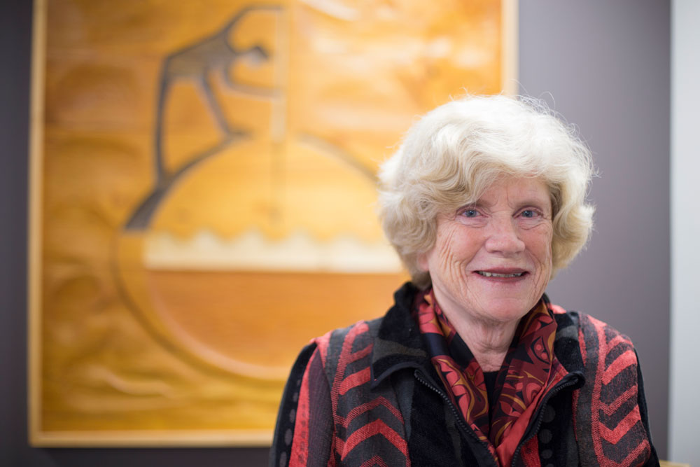
Caixia Wang, a geomatics professor, holds the unmanned aerial vehicle that she hopes will allow a thermal camera to detect melting in permafrost on Alaska's eroding coastline. (Photo by Philip Hall/University of Alaska Anchorage)
On first blush, Twitter and drones have nothing in common. But for a UAA professor of geomatics, the connection is crystal clear: location, location, location.
Let me explain. Geomatics is a new field that grew out of the traditional work of surveying and mapping. Humans have always needed to know accurate distances between places. But in 1980, a Canadian surveyor coined the new term because he realized the need for geographical information is so much more than just mapping and surveying.
In Alaska, an example of one of those new areas might be coastal erosion: When will the land no longer be there? This is exactly what geomatics professor Caixia (pronounced Kaisha) Wang is working on, but more on that in a minute.
As in so many other fields, the tools have gotten better and much more sophisticated. Thanks to progress with cameras (digital, thermal) and aviation (yes, we're talking drones and UAVs, unmanned aerial vehicles, here), the possibilities for determining distances or identifying features on the landscape have expanded dramatically.
And there was one other key development. Surveying and mapping met computer science. Now experts in geomatics capture data using remote sensing tools and then "train" computers to recognize patterns in the data. Depending on what they're studying, researchers assign values to the patterns and get a picture of what's happening in the landscape.
Professor Wang is perfecting a way to detect soil temperatures along Alaska's coastline to see if she can determine whether ice within the soil is beginning to melt. The practical applications could include forecasting coastal erosion rates and even determining timetables for moving occupants to safer ground before they face a crisis.

Wang loads a thermal camera onto this nimble drone, capable of flying very close to the surface she is studying. (Photo by Philip Hall/University of Alaska Anchorage)
She uses a thermal camera mounted on a small, nimble UAV. It is capable of vertical takeoff and landing and can fly very close to the surface she is studying. Her UAV has a power supply so it can capture the thermal camera's data and transmit it to earth.
"That makes the data live to the ground station during the flight," Wang explained. Compare that to old survey techniques-a much higher-flying, manned aircraft with a film camera; not exactly "live data during the flight."
Wang is a ways off from sending her UAVs along the Barrow coastline, which she is eager to do. Right now she's testing her UAV models, having them gather data and then confirming accuracy of the data analysis.
She's run her UAVs indoors and on private land in Portage. Next summer, she has permission to fly there along a riverbank. She'll further test her system and its accuracy. She recently applied for internal UAA funding to expand the project further-hopefully to the state's northern and western coastlines.
So the concept of "location" makes sense when you think of drones, geomatics and analyzing landscape. But what about Twitter?
That's another Wang project. Again, the link is location. She is preparing to analyze publicly available Twitter data for what the individual tweets reveals about Alaska visitors: where they go, how long they stay, what routes they take. She's using the geolocation of public Flickr photos as well.
For her, it is data analysis. Using hashtags and geolocation markers, she's comparing consumer habits and expectations with available services in the locations people visit. Given the patterns revealed through social media, are there enough hotels in a given area? Is there room for more services or different forms of recreation for the already captured audience?
She thinks there's nuance there for the tour and travel industry. Depending on the significance of her findings, she hopes to share it with industry decision makers.
Wang is from Szechuan province in southwest China, where her family still lives. She earned an undergraduate degree in survey engineering from Wuhan University, but quickly decided she liked analyzing data more than simply gathering it.
Her master's degree is from the University of Maine in Spatial Information Science and Engineering, and her doctorate is from George Mason University in Earth Systems and Geoinformation Science.
Given the titles of those degrees, that Canadian surveyor was right: There's a lot more to gathering geographical information than mapping and surveying.
A version of this story by Kathleen McCoy appeared in the Alaska Dispatch News on Sunday, Nov. 1, 2015.
 "What do Twitter and drones have in common?" is licensed under a Creative Commons Attribution-NonCommercial 4.0 International License.