


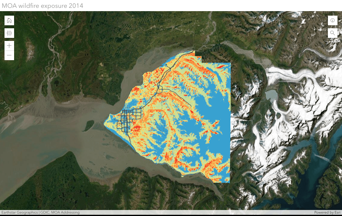
Wildfire hazard map gives residents important risk information
by Mariah Oxford |

How hazardous is your neighborhood in terms of wildfire risk? Find out with this new online map that reflects wildfire hazard potential within the municipality. Jennifer Schmidt developed the map as part of a National Science Foundation project: Arctic Urban Risks and Adaptations (AURA). Schmidt is a researcher and assistant professor of natural resources management and policy at UAA’s Institute of Social and Economic Research.
"With hotter and drier summers, wildfires in Alaska will continue to be a concern for communities and individual property owners," Schmidt said. "A lot of my work recently has focused on what we can do to mitigate the risk of wildfires. That includes assessing vegetation that provides fuel to an active fire. With this map, Anchorage residents can explore their level of risk in their own neighborhoods and take steps to mitigate it when possible."
"Early spring, while snow is on the ground, is a good time to do that," Schmidt said. "If you can get stuff out before green up, that’s ideal, but definitely before vegetation around your house gets dry and spruce bark beetles get active." The most important step is to create a defensible space around your home and remove or reduce fuel that would feed a wildfire. Alaska Firewise offers education to assist homeowners in this process.
Providing this kind of tangible, actionable information is important for Schmidt. She came to Alaska 20 years ago and is struck by how much the climate has changed in that time. "Anchorage hasn’t had a whole lot of history of wildfire. Summers have been cool. But now spring comes earlier and grasses are drier. In recent years there have been fires in the woods and here in town. People realize we have wildfire danger, and wildfires can happen very, very quickly."
Schmidt presented an early version of her map to Anchorage community councils both to raise awareness and to get feedback on making them better. This type of stakeholder collaboration is exciting, as is collaboration with her research team. "I've always been interested in interdisciplinary projects that bring together people from different backgrounds to look at a holistic system."
Schmidt regularly collaborates with climate scientists, biologists and permafrost researchers. In the process, she learns more about their specialities, but also thinks about what she can do better to pass science on to both academic and non-academic audiences.
This is especially important when interacting with stakeholders, from residents to government agencies. "They have boots on the ground and are doing fuel treatments and Firewise assessments. Figuring out what residents and communities need to make better decisions excites me. It helps translate what I am doing in front of my computer into something that turns into actions and useful tools."
Schmidt is looking into other hazards related to climate change too. She recently conducted a community survey about wildfire, permafrost thaw and icing/rain in the winter. This will help her gauge how these are affecting people and whether there is a need for education or mitigation programs.
"Permafrost thaw can be quite catastrophic to your house," Schmidt said. "It can warp your foundation, affect resale value and have a huge financial impact. We do have some permafrost issues in the Anchorage area and some residents have been negatively impacted."
Other resources for property owners that Schmidt has developed include "Lessons Learned from the McKinley Wildfire," a 2021 document that gives tips on what to do before, during and after a wildfire near your property.
 "Wildfire hazard map gives residents important risk information" is licensed under a Creative Commons Attribution-NonCommercial 4.0 International License.